Heritage of the Upper Mojave Desert
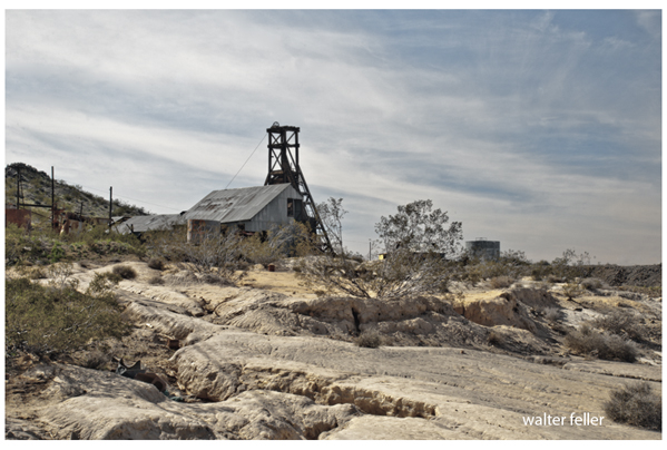
Johannesburg
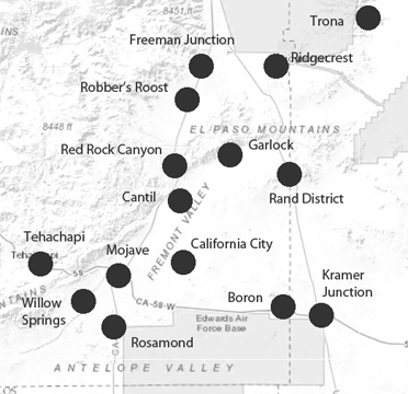
History has left an indelible mark on this vast interior region of California, embracing the northwestern part of the Mojave Desert, including the Indian Wells Valley, Searles Valley, the Rand District and Boron area. It is a land steeped in the romance and lore of a colorful past which witnessed a cavalcade of pathfinders, explorers, gold seekers, stagecoaches, and freighting wagons -- culminating with the entrance of railroads, industrial enterprises and now, the modern missile, rocket and space age.
Here is a land of contrasts. On the west rise the dramatic peaks of the Sierra Nevada. To the north and northeast are the lava-banded Coso's and the buff and brown mountains of the Argus Range, with the Slate Range as its furthest corner. On the east, the little broken ranges are an extension of the Panamints while the Kramer Hills dominate the southern stretch of this vast desert.
Before the coming of the white man, native Indians of the Shoshonean family, divided into such groups as the Panamint and Coso, roamed broad sandy valleys and mountain canyons. Farther south was the domain of the Chemehuevi, while Paiute from the north found their way into this region.
Such was the way of life until early in 1776, when Francisco Hermenegildo Garces, a missionary-priest, trudged up the Mojave River southeast of the present Boron area. He was followed a half century later by Jedediah Smith, renowned trapper and Explorer from the Midwest, who took the same route. But on the return trip from California, it is believed he crossed the Sierras to the north somewhere near Mono Lake. Thus, a new era of expiration of this part of the West came into being.
In 1834, the famous trailblazer and explorer, Joseph R. Walker, returning from the California Coast, discovered the pass through the Sierras which has been named for him. Later, he guided the Joseph B, Chiles emigrant party of 1843 through the present Indian Wells Valley and westward over the past he found a decade earlier.
In the winter of 1849-50, straggling, famished argonauts -- the Mississippi and Georgia contingent of the ill-fated Death Valley Party faltered over the Argus Range and out toward the gold fields over Walker Pass. Another contingent, made up of the Jayhawk or group, Manly, Bennett, Arcane, and Brier parties, suffering unbearably during their arduous trek, which skirted what is now Searles Lake, crossed the Argus Range, traversed the stretch of desert through the present China Lake area, and gratefully found water at the spot where the Indian Wells monument now stands. Indian Wells Valley received its name from this historic place. From there, the contingent followed the foothills of the Sierra southward through Red Rock Canyon to its final destination.
One of the Mississippi members of the Death Valley party had found a bit of silver float in one of the mountain canyons. He fashioned it into a crude gunsight, an act from which stemmed a whole legion of prospectors hunting for the fabled "Lost Gunsight Mine." These treasure seekers fanned out over the Argus, Coso, Panamint and Inyo ranges, some individually and others in well organized expeditions, such as those of Dr. Darwin French and Dr. Stanley George.
In the meantime, the influx of prospectors through the entire Mojave Desert increased in tempo. The 1850s witnessed the Kern River gold rush with towns started at Keysville, Whiskey Flat (Kernville) and Havilah. Travel came over the Walker Pass as well as Jawbone Canyon to the south, the latter route avoiding picturesque Red Rock Canyon.
In the 1860s and 1870s, the Darwin district minds, the fabulously rich Cerro Gordo, and the silver ledges of Panamint City, the latter discovered by hiding highway men, brought a new surge of humanity in search of fortune.
An interesting interlude in the procession of prospectors came about when three camels of the 1861 California-Nevada border party cross the Panamint Valley, the Coso Mountains and strode down to Walker Pass. The survey party ran out of supplies and abandoned its work around the north end of Death Valley.
As a large-scale mining activities emerged from individual prospecting, well-defined wagon roads made their appearance, supplanting the earlier trails of horsemen. Stage lines with mail and express service came up Red Rock Canyon. Near present Inyokern, they either veered northward toward Darwin or continued almost due north, following the base of the Sierra to Owens Valley. Chief figure in both stage and freight service for some time was Remi Nadeau, who headed the Cerro Gordo Freighting Company. Some 25 miles east of the present Boron area, the Myerstein stage line from San Bernardino headed north through Black Canyon, passed Granite Wells and Willow Spring in route to Panamint camp.
1 - 2 - 3 - 4 - 5 - 6 - 7 - 8 - Next
Adapted from: Romantic Heritage of the Upper Mojave Desert - A Saga of Pioneer Discoveries ... and Modern Achievements by California Interstate Telephone Company.