Chemehuevi Indians
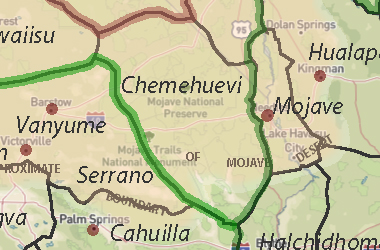
The Chemehuevi territory lay off the lower Colorado River north and west toward Death Valley and west to about the Providence Mountains. A less populated somewhat undefined strip stretched as far west as the foothills of the Sierra Nevada and north of the Mojave River. They neighbored the Koso and Serrano and were intimate with the Mohave, who after chasing the Halchidhoma and Kohuana eastward brought them to Cottonwood Island to live.
In 1867 after a war with the Mohave, the Chemehuevi, moved westward toward the Twentynine Palms area shared the Oasis of Mara with the Serrano.
Ethnology & Ethnohistory
Traditional Territory
Subsistence Resources
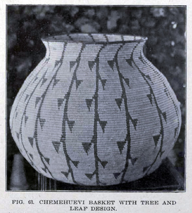
Material Culture, Technology
Trade, Exchange, Storage
Social Structure
Religion
History of the Chemehuevi
Early History
American Period
Chemehuevis at Twentynine Palms
The Establishment of the Reservation
The Willie Boy Story
Reservation Affairs
Recent Years
The Chemehuevi name for themselves is Nüwü, meaning simply, "people".
The Serrano call them Yuakayam. The Yuma call them Mat-hatevach, meaning "northerners," and the Pima: Ahalakat, "small bows".
Tribes of the Chemehuevi:
Mokwats, Yagats, Howaits, Tümplsagavatsits, Kauyaichits, Moviats
Four Directions Institute
Ethnie: CHEMEHUEVILanguage: Southern Numic
Family: Numic
Stock: Uto-Aztecan
Phylum: Aztec-Tanoan
Macro-Culture: Colorado River
Speakers ?
The Chemehuevi were hunter/farmer and hunter/gatherer tribes who ranged over the eastern half of the Mojave Desert to points on the Colorado River. Linguistically, hey are closely related to the Southern Paiute. They were friends with the Takic peoples of southern California to the west. They suffered in conflicts with the River Yuman tribes and Whites. Some western bands absorbed into the Southern California macro-culture prior to White arrival. Ultimately, many individuals absorbed into other cultures.
Aboriginal Locations
Hokwaits, Kauyaichits, Mokwats, Moviats, Palonies, Shivawach, T�mpisagavatsits, Yagats (also had 3 geographical divisions, Northern, Southern, and Desert)
Present Locations
CHEMEHUEVI RESERVATION, Havasu Lake, CA
Year History
1776 Met by Garc�s
1867 War with Mojave, fought well though out numbered, fled to desert
1898 Possible year of smallpox epidemic
Year Population Source
1700 1000 NAHDB calculation
1770 1550 Kroeber estimate (incl. Koso, Kawaiisu)
1800 900 NAHDB calculation
1873 800 US Indian Office
1900 400 NAHDB calculation
1910 300 Kroeber estimate
1973 36 BIA
1989 123 BIA
2000 150 NAHDB calculation
Other speakers of the same language:
Kawaiisu, Southern Paiute, Ute
Chemehuevi
Native Location: Southeastern California on the Arizona border and the Colorado River, from Death Valley to the Maria Mountains
Language: Paiute [Southern Numic]
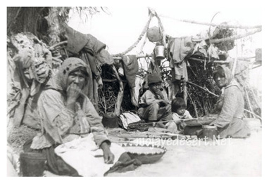
Identified Shelters: Dome-shaped structures made of sapling poles joined at the center, and thatched with brush
Food: Corn, beans, pumpkin and melon; deer, rabbit, mountain sheep
Cultural Notes: They were once nomadic; they fought and intermarried with their nearest neighbors, the Mohave.