Mojave Desert Indians
They came before time began . . .
Long before recorded history, the Mojave Desert was home to many Indigenous peoples whose lives were shaped by an intimate knowledge of water, plants, animals, and seasonal movement. What outsiders often described as a barren land was, to its original inhabitants, a place of known routes, dependable resources, and ancestral memory.
The Indigenous nations of the Mojave Desert did not exist in isolation. They formed a complex cultural landscape defined by trade, intermarriage, alliances, andat timesconflict. Trails, river corridors, mountain passes, and springs connected communities across vast distances, linking the desert to the Pacific coast, the Great Basin, and the Colorado Plateau.
The Mohave (Aha Macav)
The Mojave, who call themselves Aha Macav (People by the Water), lived primarily along the lower Colorado River. Their strategic control of this vital corridor made them influential traders and formidable defenders of their territory. Through trade networks and diplomacy, they interacted with many neighboring groups, shaping cultural exchange throughout the region.Desert and River Peoples
The Chemehuevi, a branch of the Southern Paiute, were masters of deep-desert survival. They moved seasonally between springs, seed-gathering areas, and hunting grounds, relying on careful knowledge of scarce water sources.The Vanyume, often considered a desert-dwelling subgroup of the Serrano, occupied the Mojave River corridor. Their settlements followed the rivers floodplain and adjacent springs, making them key inhabitants of one of the Mojave Deserts most important travel routes.
Mountain and Valley Nations
The Cahuilla and Serrano lived in mountain and valley environments bordering the desert. They practiced agriculture where water allowed and relied heavily on acorn harvesting, seed gathering, and trade with desert neighbors.The Tataviam, Kitanemuk, and Kawaiisu occupied territories stretching from the San Gabriel Mountains into the Tehachapi region. Their lifeways blended mountain and desert knowledge, allowing movement between ecological zones.
Farther north, the Tubatulabal lived near the Kern River, while the Northern Paiute and Western Shoshone extended into the Mojave from the Great Basin. The broader Southern Paiute world linked California, Nevada, and Utah through shared language roots, trade networks, and seasonal movement.
A Living Cultural Landscape
Together, these Indigenous nations formed a deeply interconnected cultural world. Their persistence, adaptability, and accumulated knowledge stand as clear proof of long-term human endurance in the Mojave Desertan indication that this land was never empty, never unknown, and never unused.How Indians Used Plants
Basketry
Indian use of Pinyon-juniper Woodlands
Arizona
HualapaiHavasupai
Halchidoma
Yavapai
Maricopa
A scout for the U.S. Railroad Survey in 1853 reported that A mountain range extends from San Bernardino Mountain in a southeasterly direction nearly, if not quite, to the Colorado. Between these mountains and the mountains of the Mohave nothing is known of the country. I have never heard of a white man who had penetrated it. I am inclined to the belief that it is barren, mountainous desert composed of a system of basins and mountain ranges. It would be an exceedingly difficult country to explore on account of the absence of water and there is no rainy season of any consequence.
Archaeology/Prehistory
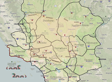
Historic Territories Map
.jpg)
Language Groups
Mohave
Chemehuevi
Cahuilla
Serrano
Vanyume
Tataviam
Kitanemuk
Kawaiisu
Tubatulabal
Northern Paiute
Southern Paiute
Owens Valley Paiute
Shoshone
Timbisha Shoshone
Western Mono
Northern Mojave: Like other remotely located tribes in California, their population has ...Koso
Northern Mojave: The Koso lived in the area east of the crest of the Sierra, south of ...Yokuts
They are subdivided into tribes, each numbering two to three hundred persons, and ...Mojave Desert Archaeology
Desert Indian Languages
The languages of the Indians in the Mojave Desert are rooted in two basic groups, that of ...Indian Slave Trade
The Indian slave trade in the desert was brutal and often deadly.What is Archaeology?
Archaeological Time Periods
Fossil Shell Layers
Lost City
Newberry Cave
Tomo-Kahni
.Atlatl Intaglio
Desert Tortoise Intaglio
Double Indian Circle
Mystery Circles
Indian Trail
Indian Bedrock Mortar
Rock Cairns
Geoglyphs
Topock Maze
Petroglyphs
Basketry
Projectile Points and Edges
"Lo! The poor Indian, whose untutor'd mind/Sees God in the clouds, or hears him in the wind..."-- Alexander Pope, Essay on Man.