Serrano Indians (Yuhaviatam)
People of the Pines
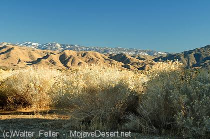
The Serrano, who call themselves Yuhaviatam, or "People of the Pines," are one of the Indigenous peoples of Southern California. Their traditional homeland includes the San Bernardino Mountains and much of the western Mojave Desert. The name "Serrano" was given by the Spanish during the mission period and means "mountaineers." Although the Spanish name remains widely used, Yuhaviatam reflects the people's own identity and long relationship with their homeland.For thousands of years the Serrano lived in a region that stretched from the forested mountains to the desert valleys below. Rather than seeing these as separate environments, they viewed them as parts of a connected landscape. Families moved seasonally between elevations, following the availability of water, plants, animals, and other resources. This movement created a deep understanding of the land that was passed from one generation to the next.
The Serrano homeland included the San Bernardino Mountains, portions of the San Gabriel Mountains east to present-day Mount Baden-Powell, the San Bernardino Valley, Cajon Pass, Summit Valley, Victor Valley, the Mojave River corridor, Lucerne Valley, Cushenbury Springs, Pipes Canyon, Morongo Valley, and the Oasis of Mara near present-day Twentynine Palms. These areas formed a continuous cultural landscape connected by trails, springs, and seasonal camps.
Like most Native peoples in California, the Serrano did not recognize rigid territorial boundaries. Neighboring territories gradually blended together, and families often shared hunting grounds, gathering areas, water sources, and travel routes through long-established agreements and kinship ties. Their closest neighbors included the Mohave, Chemehuevi, Cahuilla, Kitanemuk, Tataviam, and Tongva. Trade, marriage, ceremony, and shared knowledge connected these communities across Southern California and the Mojave Desert.
Serrano villages were generally established near dependable water sources such as springs, streams, or reliable sections of rivers. Permanent villages were occupied throughout much of the year, while temporary camps supported seasonal gathering, hunting, and travel. Well-known traditional places include Mara, Yuhaaviat, Akavat, Malki, Amaha-vit, Kayuwat, Kupacha, Pihatupayam, and Wa'acham. Many additional villages are known through oral traditions, ethnographic records, and archaeological investigations.
The Serrano viewed the land as more than a source of food and materials. Mountains, springs, rock formations, trails, and individual places held cultural and spiritual importance. Springs were especially valuable because they supported both daily life and travel across the desert. The Mojave River, Cushenbury Springs, Morongo Basin, Pipes Canyon, and numerous mountain springs served as gathering places where people exchanged goods, visited relatives, and held ceremonies.
Archaeological evidence shows that the Serrano homeland has been occupied for thousands of years. Bedrock mortars, grinding slicks, metates, manos, pottery fragments, projectile points, obsidian tools, shell beads, rock shelters, roasting pits, and village middens document a long history of settlement. Rock art and other cultural features also survive in many locations. These sites continue to provide valuable information about the history of the region while remaining important cultural places for descendant communities.
The Serrano practiced a seasonal hunter-gatherer economy that made use of the diverse environments within their homeland. Plant foods included acorns, pinyon pine nuts, manzanita berries, yucca fruits and flower stalks, mesquite beans, screwbean pods, chia, cactus fruits, juniper berries, seeds, and edible greens. Food was dried, roasted, ground into meal, or stored for later use.
Animal resources included mule deer, rabbits, jackrabbits, mountain sheep, quail, waterfowl, reptiles, fish where available, and many smaller mammals. Hunting methods included the use of bows and arrows, traps, nets, and detailed knowledge of animal behavior. Seasonal movement allowed families to take advantage of resources as they became available throughout the year.
Serrano material culture reflected practical knowledge developed over many generations. They produced finely woven baskets for gathering, cooking, storage, and ceremonial use. Stone tools, wooden implements, nets, cordage, rabbit-skin blankets, pottery, and digging sticks supported daily life. Many of these technologies were adapted to local conditions and available natural materials.
Trade played an important role in Serrano society. Their homeland occupied a strategic position between the Pacific coast, the Great Basin, and the lower Colorado River. Ancient trails connected Serrano communities with neighboring peoples, allowing the exchange of shell beads, obsidian, steatite, pigments, basketry, hides, salt, food resources, medicinal plants, and ceremonial knowledge. Many of these same routes were later used by Spanish explorers, traders, military expeditions, and American emigrants.
Serrano society was organized around extended families living in village communities. Many villages belonged to one of two traditional exogamous moieties known as Coyote and Wildcat. Marriage between members of opposite moieties strengthened social relationships and helped maintain connections among communities. Leadership generally rested with respected hereditary leaders whose authority depended upon experience, consensus, and responsibility for the welfare of the community.
Traditional Serrano beliefs emphasized the relationship between people, the natural world, and their ancestors. Oral traditions, ceremonies, songs, and creation narratives preserved cultural knowledge and reinforced responsibilities toward the land. Among the best-known traditional accounts are those preserved through the work of Serrano elder Dorothy Ramon.
Spanish explorers first entered Serrano territory during the 1770s. Beginning around 1790, increasing mission activity changed traditional life as many Serrano were baptized and relocated to Mission San Gabriel and later the San Bernardino Asistencia. Disease, forced labor, and population decline greatly affected Serrano communities during both the Spanish and Mexican periods.
Following Mexican independence in 1821, mission lands were secularized and divided into ranchos. Traditional hunting and gathering areas increasingly came under private ownership, while Native labor remained important to regional ranching operations.
After the United States acquired California in 1848, mining, ranching, transportation, and settlement expanded throughout Serrano territory. Smallpox epidemics, violence, displacement, and military campaigns further reduced the population. Conflicts during the 1860s in the San Bernardino Mountains and surrounding desert marked one of the most difficult periods in Serrano history.
Reservations established later in the nineteenth century provided permanent homes for many surviving families. Today many Serrano descendants are members of the San Manuel Band of Mission Indians and the Morongo Band of Mission Indians, while others maintain their heritage through neighboring tribal communities and family traditions.
The Serrano language belongs to the Northern Takic branch of the Uto-Aztecan language family. It is closely related to Kitanemuk, Tongva, and Tataviam. Although the number of fluent speakers declined during the twentieth century, language revitalization programs continue through tribal education and cultural preservation efforts.
Today the Serrano remain an active and living people. Tribal governments, educators, historians, archaeologists, artists, and cultural leaders continue to preserve language, oral history, traditional knowledge, and important cultural places. Traditional ecological knowledge also contributes to the protection of archaeological sites, native plants, wildlife, springs, and culturally significant landscapes throughout the San Bernardino Mountains and the western Mojave Desert.
The history of the Serrano demonstrates a continuing relationship with their homeland that extends from prehistoric times to the present. Their knowledge of mountain forests, desert valleys, seasonal resources, and ancient travel routes remains an essential part of understanding the human history of the Mojave Desert and Southern California.
The Serrano, who traditionally call themselves Yuhaviatam ("People of the Pines"), are one of the Indigenous peoples whose homeland spans the San Bernardino Mountains and the western Mojave Desert of Southern California. The name Serrano was applied by the Spanish during the mission era and simply means "mountaineers." While widely used today, it does not reflect the people's own name for themselves.
For thousands of years the Serrano developed an intimate knowledge of mountain forests, desert valleys, springs, and seasonal travel routes. Their homeland was not divided into separate mountain and desert worlds. Instead, these environments formed a single cultural landscape connected by trails, family relationships, trade, and seasonal movement.
The Serrano remain a living people whose descendants continue to preserve their language, traditions, and cultural identity through tribal governments, cultural programs, and educational efforts.
Traditional Territory
The Serrano homeland extended across much of the San Bernardino Mountains, portions of the San Gabriel Mountains, the upper Santa Ana River watershed, and large areas of the western Mojave Desert.Their territory generally included:
San Bernardino Mountains
San Gabriel Mountains east to Mount Baden-Powell
San Bernardino Valley
Cajon Pass
Summit Valley
Victor Valley
Mojave River corridor
Lucerne Valley
Cushenbury
Pipes Canyon
Morongo Valley
Oasis of Mara (Twentynine Palms) Rather than fixed political borders, neighboring Indigenous territories usually blended gradually into one another. Families often shared hunting grounds, gathering areas, springs, and travel routes with neighboring peoples through long-established agreements and kinship ties.
The Serrano interacted regularly with the Mohave, Cahuilla, Chemehuevi, Kitanemuk, Tataviam, and Tongva, creating one of Southern California's most interconnected cultural landscapes.
Traditional Villages
The Serrano occupied numerous permanent villages and seasonal camps throughout their homeland. Communities were typically located near dependable springs, streams, or oak groves, while temporary camps supported seasonal hunting and gathering.Known villages include:
Akavat
Amaha-vit
Kayuwat
Kupacha
Mara
Malki
Pihatupayam
Wa'acham
Yuhaaviat
Many additional village locations are known through oral traditions, ethnographic records, and archaeological investigations.
Cultural Landscape
To the Serrano, the land was far more than a collection of resources. Mountains, springs, rock formations, and trails formed a living landscape filled with history, meaning, and responsibility.Seasonal travel linked mountain villages with desert camps. Families gathered pine nuts in higher elevations during autumn, harvested acorns from oak woodlands, collected yucca, mesquite, cactus fruits, and other desert plants, and hunted deer, rabbits, mountain sheep, and smaller game.
Springs were among the most important places within Serrano territory. Reliable water sources along the Mojave River, in Pipes Canyon, and throughout the Morongo Basin served as gathering places for travel, trade, ceremony, and community life.
Archaeological Evidence
Archaeological evidence shows that the Serrano homeland has been occupied for thousands of years.Evidence includes:
bedrock mortars
grinding slicks
metates and manos
habitation sites
pottery fragments
projectile points
obsidian tools
shell beads
rock art
village middens
roasting pits
rock shelters
Many archaeological sites remain protected because of their cultural importance to descendant communities.
Subsistence
The Serrano practiced a seasonal hunter-gatherer economy that took advantage of the remarkable diversity found between the mountains and desert.Important plant foods included:
acorns pinyon pine nuts manzanita berries yucca fruits and flower stalks mesquite beans screwbean pods chia cactus fruits juniper berries seeds greens Animal resources included: mule deer rabbits jackrabbits mountain sheep quail waterfowl reptiles fish where available small mammals Foods were dried, roasted, ground into meal, or stored for later use. Material Culture The Serrano produced finely woven baskets, stone tools, wooden implements, nets, carrying bags, rabbit-skin blankets, pottery, and cordage. Basketry served many purposes, including food gathering, cooking, storage, seed processing, and ceremonial activities. Bow and arrow technology, traps, nets, digging sticks, and carefully crafted stone tools reflected generations of environmental knowledge. Trade and Exchange The Serrano occupied an important crossroads between coastal Southern California, the Great Basin, and the lower Colorado River. Trade connected them with the Mohave, Chemehuevi, Cahuilla, Tongva, Kitanemuk, and Tataviam. Items exchanged included: shell beads obsidian steatite pigments basketry salt hides food resources medicinal plants ceremonial knowledge Many of these exchanges followed ancient trail systems later used by Spanish explorers, traders, emigrants, and military expeditions. Social Organization Serrano society centered on extended families organized into autonomous village communities. Many villages belonged to one of two traditional exogamous moieties, commonly identified as Coyote and Wildcat. Marriage between members of opposite moieties strengthened relationships between communities and helped maintain social balance. Leadership generally rested with respected hereditary leaders whose authority depended upon consensus, experience, generosity, and the welfare of the community. Religion and World View Traditional Serrano beliefs emphasized respect for the natural world, ancestral knowledge, and the responsibilities shared between people, animals, plants, and the landscape. Creation stories, songs, ceremonies, and oral traditions preserved knowledge across generations and reinforced the community's relationship with the land. Among the best-known traditional narratives are those preserved by Serrano elder Dorothy Ramon. History Before European Contact For thousands of years the Serrano occupied the San Bernardino Mountains and the western Mojave Desert, developing extensive knowledge of seasonal resources, travel routes, neighboring peoples, and the natural environment.
Spanish Period
Spanish explorers first entered Serrano territory during the 1770s. Beginning about 1790, missionization dramatically altered traditional life as many Serrano were baptized and relocated to Mission San Gabriel and later the San Bernardino Asistencia. Disease, forced labor, and population loss severely affected Serrano communities.Mexican Period
Following Mexican independence in 1821, mission lands became ranchos. Traditional hunting and gathering areas increasingly came under private control while Native labor continued to support regional ranching operations.American Period
The arrival of American settlers after 1848 brought mining, ranching, military campaigns, and increasing settlement throughout Serrano territory. Smallpox epidemics, violence, and displacement further reduced the population. During the 1860s, conflicts in the San Bernardino Mountains and surrounding deserts marked one of the most difficult periods in Serrano history. Reservations established later in the nineteenth century provided a permanent homeland for many surviving families.Present-Day Serrano
Today the Serrano continue to preserve their cultural heritage through tribal governments, language revitalization, cultural education, archaeology, traditional arts, and environmental stewardship. Many Serrano descendants are enrolled in the San Manuel Band of Mission Indians and the Morongo Band of Mission Indians, while other families maintain their heritage through neighboring tribal communities and independent cultural organizations. Traditional ecological knowledge continues to guide the protection of sacred places, archaeological sites, native plants, wildlife, and culturally significant landscapes throughout Southern California and the Mojave Desert.Timeline
1771 - Mission San Gabriel founded 1772 - Pedro Fages enters Serrano territory 1776 - Francisco Garces travels through the region 1790s - Missionization accelerates 1812 - Regional Native uprising affects Southern California missions 1821 - Mexican independence 1840 - Smallpox epidemic 1848 - American control begins 1851 - California treaty negotiations (never ratified) 1866-1867 - Military campaigns in the San Bernardino Mountains 1875 - San Manuel Reservation established 1891 - Morongo Reservation established 1900s-Present - Cultural preservation and language revitalization Language The Serrano language belongs to the Northern Takic branch of the Uto-Aztecan language family. It is closely related to Kitanemuk, Tongva, and Tataviam. Although the number of fluent speakers declined during the twentieth century, language revitalization efforts continue through tribal educational programs and cultural preservation initiatives. Population Estimates 1700 - Approximately 1,500 1770 - Approximately 1,500 1900 - Approximately 100 Today - Several thousand descendants enrolled in or affiliated with Serrano communities Related Topics Traditional Territory of Mojave Desert Tribes Mojave Desert Archaeology Mojave River Oasis of Mara San Bernardino Mountains Vanyume Kitanemuk Mohave Cahuilla Chemehuevi Indigenous Trails of the Mojave Desert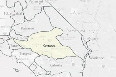
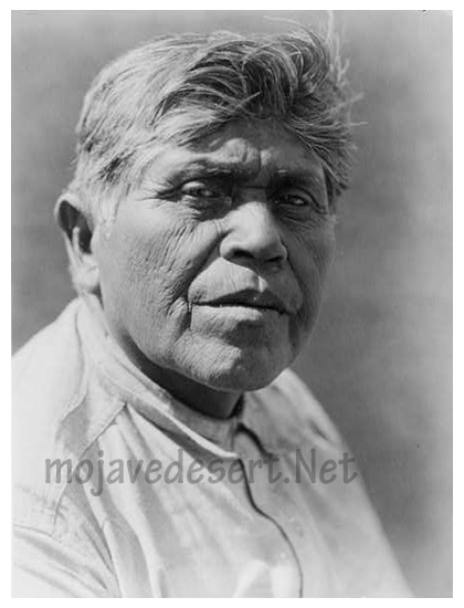
Tejon Serrano man (E. Curtis 1924)
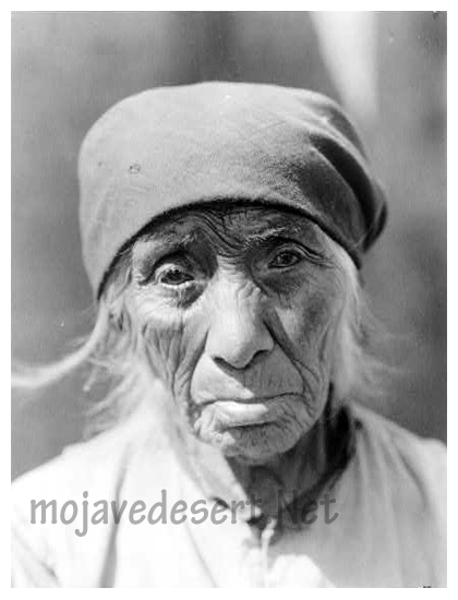
Tejon Serrano woman (E. Curtis 1924)
Language: Takic branch of Uto-Aztecan
Cultural Notes: They were once sedentary hunter-gatherers. Serrano is Spanish for "mountaineer", but they called themselves Yuharetum, which means "people of the pines."