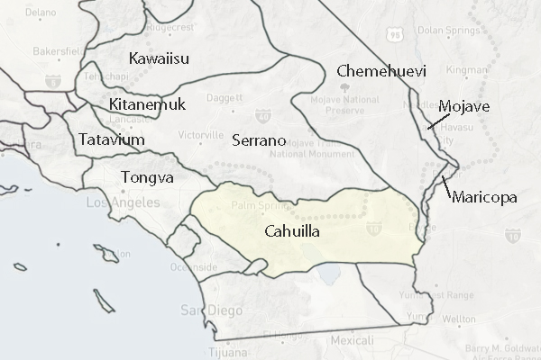
Traditional Territory - Cahuilla Indians
In the Claims Case, the Cahuilla claimed the following:
Beginning at a point which is approximately 7'/2 miles North and 10 miles East of Volcan Mountain;
thence Easterly in an irregular line to a point in the area of the Salton Sea, which is approximately
14 miles West from the town of Niland; thence Northeasterly in an irregular line to a point which is
approximately 12 miles West of the Colorado River and three miles South of the Riverside-San Diego
County line; thence Northerly in an irregular line parallel with and approximately 12 miles Westerly
of the Colorado River to a point due West from Blythe; thence Westerly in an irregular line to the
approximately area of the present Hayfield Reservoir on the Colorado River Aqueduct; thence Westerly
in an irregular line following the line of said Aqueduct to a point due North from San Jacinto Peak;
thence South in an irregular line to the approximate area of San Jacinto Peak; thence Southeasterly in
an irregular line to the approximate area of Lookout Mountain; thence Westerly in an irregular line to
Coahuilla Mountain; thence Southwesterly in an irregular line to a point approximately 2 miles South
from the town of Sage; thence Southeasterly in an irregular line to a point which is approximately 9
miles Northwest from the top of Hot Springs Mountain; thence Southeasterly in an irregular line to a
point which is approximately 4 miles North from said top of Hot Springs Mountain; thence South in an
irregular line approximately 4 miles to the approximate area of Hot Springs Mountain; thence Easterly
in an irregular line to a point that is approximately 3 miles North from the point of beginning;
thence South approximately 3 miles to the point of beginning (U.S. Court of Claims 1950-1960: Docket 80).
The Cahuillas' easternmost known rancherias lay in the Coachella Valley at the northern end
of Lake Cahuilla. Cahuillas from here, and perhaps from other Cahuilla groups, hunted in the
desert areas to the east, and entered the Project Area from time to time to gather special
plant resources. Saturnino Tones, an elder at Tones-Martinez Indian Reservation, remembers
hunting in the Eagle Mountain area when he was young (Bean and Vane 1990).
Ecological Settings
Southern California Mountains and Valleys
Fontana Plain - Calimesa Terraces
Desert Slopes
San Jacinto Mountains
San Jacinto Foothills - Cahuilla Mountains
Little San Bernardino - Bighorn Mountains
Sonoran Desert
Colorado Desert
Introduction
Material Culture, Technology
Trade, Exchange, Storage
Social Structure
Religion
History
Timeline
Traditional Territory
Major Sources
Northern Colorado Desert, Joshua Tree National Park