A Classic American Desert
The Mojave Desert is a hot and dry region surrounded by mountains. The Sierra Nevada, San Gabriel, and San Bernardino Mountains block wet air from the Pacific Ocean, leaving the Mojave on the east side in an area called a "rain shadow." This makes the desert very dry. To the east, the Mojave connects to the Colorado Plateau. Its northern border is adjacent to the Great Basin Desert, while its southern border is abutting the Sonoran Desert.Weather and Rain
The Mojave Desert doesn't get much rain, and how much it gets varies by where you are:Rain falls rapidly in brief spells during summer monsoons and comes down heavier in winter, with February being the month that has the most rain. Summers are very hot with temperatures above 105F, but winters can be cold, especially in the mountains, where it can sometimes snow. The Mojave Desert is what you think of when you hear the term "classic American desert," but it's more special than just sand dunes and flat land. This desert has many differences, where sharp mountains rise high above the wide valleys, making impressive viewsTelescope Peak in Death Valley, 3,400 meters high, and Badwater Basin, 88 meters lowall within just 23 kilometers of each other.
Mountains and Alluvial Fans
The Mojave's mountains are not just still they are changing all the time. After storms, rocks and debris fall out of canyons and spread into big, fan-shaped areas called alluvial fans. When these fans come together, they form bajadas long, sloping lands filled with tough plants like creosote bushes and cacti. Over time, these bajadas get capped with desert pavementa layer of gravel and rock coated with a natural varnish formed by iron and manganese cemented to the surface over millennia. These great bajadas dominate the Mojave's terrain, an ever-changing view of geologic processes.Basin and Playa
Rainfall in the Mojave does not flow away it collects in low areas where it eventually turns into vapor, leaving large, flat areas of white salty deposits called playas. These empty dry lakebeds, such as Soda Lake at the end of the Mojave River, are some of the flattest natural features on Earth, sharply contrasting with the brown colors of the desert around them.A Geological Time Capsule
The Mojave is part of the Basin and Range Province, with its long mountain ranges and wide valleys. Its rocks show a history going back 2.7 billion yearsmore than half of the Earth's history. Fossils from shallow seas in the Paleozoic era prove that the Mojave was once under the sea, and limestone formations prove that these old marine environments existed.The Mesozoic era brought uplift, salt deposits from evaporating seas, and rivers carrying sediments to lowlands that helped shape much of the region we see today.
Dunes and Sandstone
During the Mesozoic, the Mojave became drier and windier, creating dunes. Wind-carved patterns in sandstone, similar to those found in Nevada's Red Rock Canyon, show this time of change.Faults, volcanoes, and earthquakes. The Cenozoic era was a time of big changes in the Earth's surface. Faults changed sedimentary layers, pushing older rocks over younger ones. Volcanic activity created new features like cinder cones and lava flows. Eruptions, such as the one that occurred 17.8 million years ago in the Woods Mountains, left ash layers that kept fossils of ancient life safe. The Mojave is still active in geology, located on an "accommodation zone" between the Pacific and North American tectonic plates. Earthquakes like the 1992 Landers quake (magnitude 7.6) and the 1999 Hector Mine quake (magnitude 7.1) show us the strong forces still changing this desert area. A Changing Desert Even though it is not like a typical desert, the Mojave has rough mountains, sandy areas, dry lake beds, and a rich geological past, making it one of the most interesting places on Earth. Here, time is marked in the ground, sharing stories that go back billions of years. Also see:
Mojave Desert Geology
Application of the natural sciences to the physical formations found inside and on the ...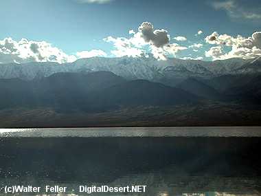
Telescope peak during flooding of Badwater is remniscent of ancient lakes - Death Valley - Springs
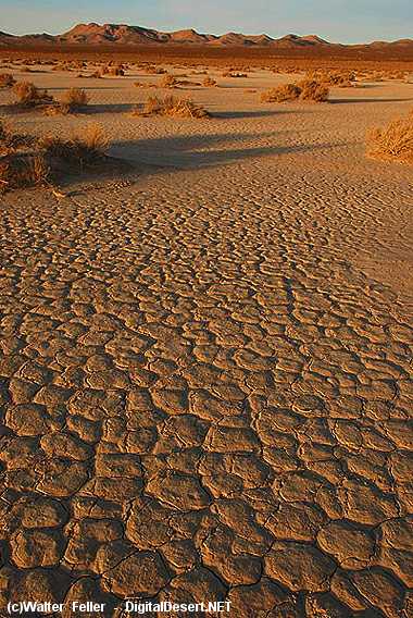
El Mirage dry lake (playa) - Dry Lakes
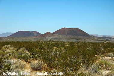
Cinder cone field - Mojave National Preserve - Craters & Volcanic Features
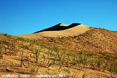
Kelso sand dunes - Mojave National Preserve - Sand Dunes