Traditional Territory
In the Claims Case, the Mojave claimed the following:
All of the Mojave Valley of the Colorado River, extending north to the Black Canyon in said river, extending
south to the Mojave Mountains; extending east to the highest crest of the Black Mountains, to the Buck Mountains
and to the Mojave Mountains; and extending west to the Sacramento Mountains, the
Dead Mountains,
and to the
Newberry Mountains.
All of the lands on both banks of the
Colorado River
extending from the midstream of said river back on
either side of said river, to the crest of the mountain; bordering on said portion of said river and
extending north to the Mohave Valley in said river, and extending south to a point below what is now
known as and called the City of Blythe, in the County of Riverside, State of California.
All of that part of what is now known as the Mojave Desert in the State of California, extending east
to the land above described located on the Colorado River extending south to the
Whipple Mountains, the
Turtle Mountains,
the Granite Mountains, the Eagle Mountains, the little San Bernardino Mountains, the
San Bernardino Mountains;
extending west to the
San Gabriel
and Tehachapi Mountains, and extending
north as far as the Granite,
Soda Lake,
Providence and New York Mountains, including the valley now
known as Paiute Valley extending north into the
State of Nevada
(U.S. Court of Claims 1950-1960: Docket 283)
[CSRI emphasis].
While the Mojaves centered their activities along the Colorado River, where they practiced agriculture
in the flood plain, they maintained an active trading relationship with the
Serrano
and the peoples of
the coast, and traveled through the Project Area on a fairly regular basis. They hunted the game in
the area and gathered plant products on occasion. After European contact, they supplemented their
other resources by raiding the mission and Mexican rancheros for cattle and horses and may have come
through what is now the
Joshua Tree National Park
on some of these raids.
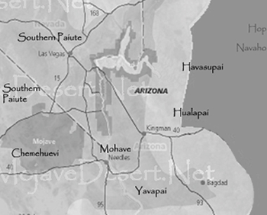
Mojave Indian Territorial Map
About the Territory:
California Geomorphic Region
... naturally defined geologic regions that display a distinct landscape or ...
- Mojave Geomorphic Province
... a broad interior region of isolated mountain ranges separated by expanses of desert ...
Widely separated short ranges in desert plains. Contains isolated mountains, plateaus, alluvial fans, playas, ...
- Paiute Valley Ecosubsection
... steep to very steep mountains, gently to moderately sloping pediments and alluvial fans, and nearly level ...
- Dead Mountains
... the Dead Mountains runs north to south and is a jagged, steep, rust-colored range crowned ...
- Chemehuevi Mountains
These mountains transform gradually from almost white granite to dark red and gray volcanic ...
- Whipple Mountains
The landscape is diverse, ranging from valley floors and washes to steep-walled canyons, domed peaks and eroded spires ...