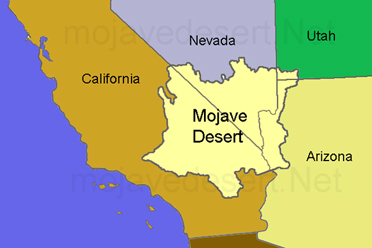
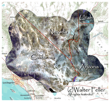
Digital-Desert : Mojave Desert Desert Gazette
features - ecology: wildlife - plants - places - region map - map/sat - roads & trails - wilderness - video - aerial - 360 - old west - communities - books - lodging
route 66 - ghost towns - gold mines - parks & ... - joshua tree - death valley - mojave preserve - native culture - history - natural features - geology - glossary - comments


What & Where is the Mojave Desert?

Good question, glad you asked... Let me over explain.

The Mojave or Mohave Desert occupies a significant portion of Southern California and parts of Utah, Nevada, and Arizona. Named after the Mohave Native Americans it occupies roughly 54,000 square miles in a typical Basin and Range topography.

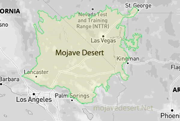
The Mojave Desert is bound in part on the western end by the Tehachapi together with the San Gabriel and San Bernardino mountain ranges. The mountain boundaries are quite distinct since they have been created by the two largest faults in California: the San Andreas and the Garlock. Its northern and eastern boundaries are less distinct. One way to determine location is by observing the presence of Joshua Trees. 
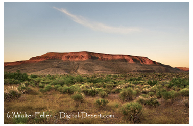
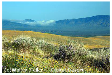
The Mojave Desert receives less than 6 inches of rain a year and is generally between 3,000 and 6,000 feet in elevation. The Mojave Desert also contains the Mojave National Preserve, Joshua Tree National Park and the lowest-hottest place in North America: Death Valley, where the temperature can approach 120F in late July and early August.


The Mojave, like all deserts in general, is known for its summer heat, however, there is wintertime cold. Snow, although uncommon, does fall in parts of the Mojave. Amounts range from just a trace to a foot or more of heavy wet snow which can lead to freeway traffic closures and being "snowed in". The coldest wintertime temperature ranges below freezing yet above 0F. Many parts of the Mojave typically range from highs of around 95-105F in the summer to lows of around 20-30F in the winter.

High winds, often above 50 miles per hour, are also a weather factor and occur frequently along the western end of the Mojave, and are less common toward the east.

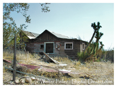
The Mojave Desert contains a number of ghost towns. The most well known of these being the silver-mining town of Calico, California. Some of them are of the more modern variety created when Route 66 was abandoned in favor of the Interstates. Among the more popular and unique tourist attractions in the Mojave is the self-described World's Largest Thermometer at 135 feet high, reportedly also the highest temperature ever recorded in the region located along Interstate 15 in Baker, California.


The Mojave River is an important source of water in this arid land. A part of the Colorado River traverses its far eastern portion.

The Mojave Desert is crossed by major highways Interstate 15, Interstate 40, US Highway 395 and US Highway 190.

Some of the cities in the Mojave Desert include Victorville, Barstow, Palmdale, Ridgecrest, and Needles, California. Las Vegas, Nevada is the Mojave's largest city and metropolitan area.

Regionally, the southwest portions, the Antelope Valley, the Victor Valley, the Lucerne Valley and the Yucca Valley / Twentynine Palms areas are refered to as the High Desert.

Shaping the "Classic American Desert"
... the Mojave does not really fit the classic image of ...

Life at the Extremes
The Mojave Desert, the driest and smallest of the ...

Adaptations
The Mojave Desert is an environment of extreme heat, ...

Plants
... plants that have developed special means of storing and ...

Animals
Desert animals are more susceptible to temperature extremes than ...

Early Man
... results show that Paleoindians may have reached this area as ...

Miners, Homesteaders, and Route 66
During the mid-19th century, mining in all areas of the Mojave created ...

Desert Tortoise
... as a threatened species in large parts of its range, it has become ...

Sensitive Fish Species
... more than half of the native desert fish species in the Mojave ...

Rising to the Occasion
As more people seek escape from the congestion of nearby ...

Management Challenges
But because ecosystems do not recognize such boundaries, ...

Water
Groundwater and the Mojave and Colorado Rivers are the ...

Off-Highway Vehicles
... riding motorcycles, all-terrain vehicles, dune buggies, and ...

Fire and Weeds
... not common in the Mojave Desert, and when they did occur, ...


Snow in the desert

Joshua Tree National Park

Ghost Towns

Ballarat

Joshua Trees

Antelope Valley

Sand dunes

Kelso Dunes

Springs & Oases

Oasis of Mara

Rivers

Colorado River

Dry Lakes

El Mirage Dry Lake

Wildlife

Antelope Ground Squirrel

Cities

Victor Valley

features - ecology: wildlife - plants - places - region map - map/sat - roads & trails - wilderness - video - aerial - 360 - old west - communities - books - lodging
route 66 - ghost towns - gold mines - parks & ... - joshua tree - death valley - mojave preserve - native culture - history - natural features - geology - glossary - comments
Wrightwood Real Estate
MOUNTAIN HOMES & CABINS
Vacation Rentals & Homes for Sale
Log Cabin Furnishings
Lodgepole Pine Log Furniture
Rustic Decor & Silhouette Metal Art
HighDesertRED.com
High Desert Real Estate Directory
--
Google
Search:
Keywords:
Check out our...
>> RECOMMENDED BOOK LISTS <<
Digital-Desert
Abraxas Engineering
privacy
Copyright ©Walter Feller. All rights reserved.
Respect U.S and international copyright statutes and our right to own and control our work
- DO NOT LINK TO THESE IMAGES FROM WEB PAGES, FORUMS OR BLOGS -
Desert Gazette
60895