Part-time Prospector
Ore Discovered in Ord Mountains
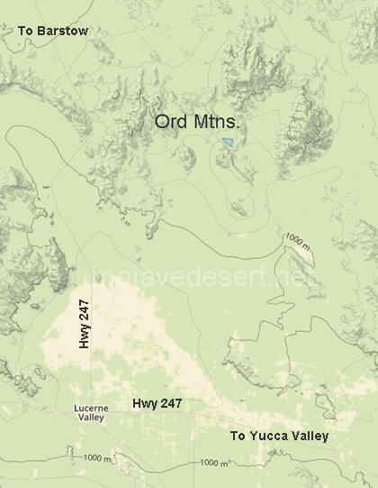
With the success of the Ivanpah mines, prospectors began to look elsewhere in the desert. Their search eventually led them to the Ord Mountains, a dark and rugged chain located over 20 miles southwesterly of Camp Cady and about 16 miles northeasterly of present-day Lucerne Valley (a different range than the Ord Mountains in the Apple Valley Highlands).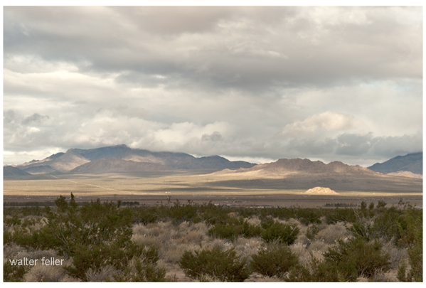
The central peak of the chain is Ord Mountain, which, at 6,309 feet above mean sea level, is the tallest peak in the highest range of the south-central part of the Mojave Desert. It is flanked by East Ord Mountain, which rises to 6,068 feet above sea level, and West Ord Mountain, with an elevation of 5,525 feet. It has been said that an ex-soldier named the mountain for General Edward O. C. Ord, under whom he had served. According to James Crossman, outcroppings of mineral veins were originally discovered on Ord Mountain by soldiers from Camp Cady who were sent there to investigate Indian signal fires that had been observed in the area. The troops reported back that there was an Indian stronghold on the mountain, where numerous streams could be seen running down into the desert.
While on the northern slope, they also had discovered an outcropping of a strong vein which could be traced for several miles. A close examination of the rock revealed particles of gold and a copper stain. When the site was revisited, it was determined that the location was at the western extremity of the mountain range in Township 7 North, Range 1 East, seven and one-half miles south of Daggett measured on a straight line, and at an elevation of 4,500 feet above sea level.
In Carleton's Paiute Campaign, historian and publisher Dennis G. Casebier chronicles an incident that occurred in the same vicinity, and that to some extent matches Crossman's story. On the first of May, 1860, Major Carleton and a small detachment were scouting south of Camp Cady when a large body of Indians was spotted on a high mountain.
The Indians had taken cover in a very rocky area at the peak and could not be dislodged during the day. At night they whooped at the soldiers and shot their rifles into the military camp, which was located in the mouth of a ravine near a spring (Casebier believes this camp may have been at Aztec Spring, situated on the northern slope of what today is known as Ord Mountain). The next day the Indians shot at the soldiers from the mountain peaks, fleeing whenever the troops looked as though they were going to pursue them. Major Carleton burned their rancheria together with all the Indians' property and then proceeded to Camp Cady.
The Major later returned with 30 soldiers during a night march. He succeeded in getting 20 of the men to the highest point of the mountain, where they hid among the rocks, and the other ten were sent to where the Indians had last been sighted. But their efforts were to no avail, as the Indians had left the area. In checking their trail, Carleton estimated that there must have been 60 to 70 in the party.
If this action did take place at Ord Mountain -- and the descriptions by Carleton seem to fit -- then it is possible the soldiers did spot the mineral outcropping at that time, thus giving credence to Crossman's story. That the discovery was not exploited might be explained by the fact that the troops left the desert soon after the Ord Mountain encounter, and for several years the Mojave was once again almost solely the domain of the Indians. The state of the general economy was also a factor that could explain the delay of eleven years before a mining district was organized; money was very scarce, and mining development throughout the West suffered.
< Previous - Next >
-=-