The Mesa Trail
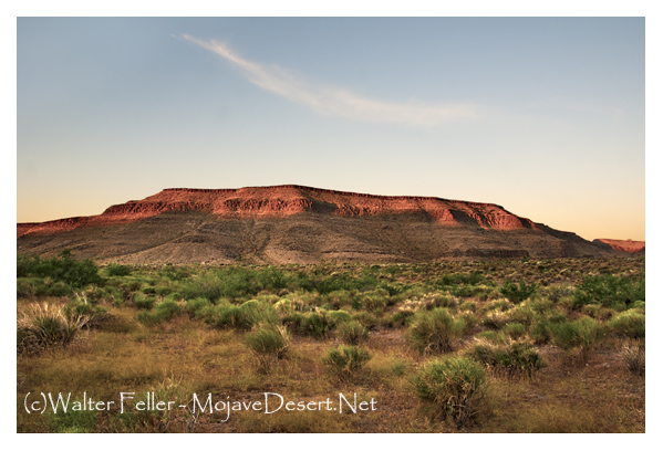
The mesa trail begins in the campoodie at the corner of Naboth's field, though one may drop into it from the wood road toward the canon, or from any of the cattle paths that go up along the streamside; a clean, pale, smooth-trodden way between spiny shrubs, comfortably wide for a horse or an Indian. It begins, I say, at the campoodie, and goes on toward the twilight hills and the borders of Shoshone Land. It strikes diagonally across the foot of the hill-slope from the field until it reaches the larkspur level, and holds south along the front of Oppapago, having the high ranges to the right and the foothills and the great Bitter Lake below it on the left. The mesa holds very level here, cut across at intervals by the deep washes of dwindling streams, and its treeless spaces uncramp the soul.Mesa trails were meant to be traveled on horseback, at the jigging coyote trot that only western-bred horses learn successfully. A foot-pace carries one too slowly past the units in a decorative scheme that is on a scale with the country round for bigness. It takes days' journeys to give a note of variety to the country of the social shrubs. These chiefly clothe the benches and eastern foot-slopes of the Sierras, — great spreads of artemisia, coleogyne , and spinosa, suffering no other woody stemmed thing in their purlieus; this by election apparently, with no elbowing; and the several shrubs have each their clientele of flowering herbs. It would be worth knowing how much the devastating sheep have had to do with driving the tender plants to the shelter of the prickle-bushes. It might have begun earlier, in the time Seyavi of the campoodie tells of, when antelope ran on the mesa like sheep for numbers, but scarcely any foot-high herb rears itself except from the midst of some stout twigged shrub; larkspur in the coleogyne , and for every spinosa the purpling coils of phacelia. In the shrub shelter, in the season, flock the little stemless things whose blossom time is as short as a marriage song. The larkspurs make the best showing, being tall and sweet, swaying a little above the shrubbery, scattering pollen dust which Navajo brides gather to fill their marriage baskets. This were an easier task than to find two of them of a shade. Larkspurs in the botany are blue, but if you were to slip rein to the stub of some black sage and set about proving it you would be still at it by the hour when the white gilias set their pale disks to the westering sun. This is the gilia the children call "evening snow," and it is no use trying to improve on children's names for wild flowers.
From the height of a horse you look down to clean spaces in a shifty yellow soil, bare to the eye as a newly sanded floor. Then as soon as ever the hill shadows begin to swell out from the sidelong ranges, come little flakes of whiteness fluttering at the edge of the sand. By dusk there are tiny drifts in the lee of every strong shrub, rosy-tipped corollas as riotous in the sliding mesa wind as if they were real flakes shaken out of a cloud, not sprung from the ground on wiry three-inch stems. They keep awake all night, and all the air is heavy and musky sweet because of them.
Farther south on the trail there will be poppies meeting ankle deep, and singly, peacock-painted bubbles of calochortus blown out at the tops of tall stems. But before the season is in tune for the gayer blossoms the best display of color is in the lupin wash. There is always a lupin wash somewhere on the mesa trail, — a broad, shallow, cobble-paved sink of vanished waters, where the hummocks of Lupinus ornatus run a delicate gamut from silvery green of spring to silvery white of winter foliage. They look in fullest leaf, except for color, most like the huddled huts of the campoodie, and the largest of them might be a man's length in diameter. In their season, which is after the gilias are at their best, and before the larkspurs are ripe for pollen gathering, every terminal whorl of the lupin sends up its blossom stalk, not holding any constant blue, but paling and purpling to guide the friendly bee to virginal honey sips, or away from the perfected and depleted flower. The length of the blossom stalk conforms to the rounded contour of the plant, and of these there will be a million moving indescribably in the airy current that flows down the swale of the wash.
There is always a little wind on the mesa, a sliding current of cooler air going down the face of the mountain of its own momentum, but not to disturb the silence of great space. Passing the wide mouths of canons, one gets the effect of whatever is doing in them, openly or behind a screen of cloud, — thunder of falls, wind in the pine leaves, or rush and roar of rain. The rumor of tumult grows and dies in passing, as from open doors gaping on a village street, but does not impinge on the effect of solitariness. In quiet weather mesa days have no parallel for stillness, but the night silence breaks into certain mellow or poignant notes. Late afternoons the burrowing owls may be seen blinking at the doors of their hummocks with perhaps four or five elfish nestlings arow, and by twilight begin a soft whoo-oo-ing , rounder, sweeter, more incessant in mating time. It is not possible to disassociate the call of the burrowing owl from the late slant light of the mesa. If the fine vibrations which are the golden-violet glow of spring twilights were to tremble into sound, it would be just that mellow double note breaking along the blossom-tops. While the glow holds one sees the thistle-down flights and pouncings after prey, and on into the dark hears their soft pus-ssh! clearing out of the trail ahead. Maybe the pinpoint shriek of field mouse or kangaroo rat that pricks the wakeful pauses of the night is extorted by these mellow-voiced plunderers, though it is just as like to be the work of the red fox on his twenty-mile constitutional.
Both the red fox and the coyote are free of the night hours, and both killers for the pure love of slaughter. The fox is no great talker, but the coyote goes garrulously through the dark in twenty keys at once, gossip, warning, and abuse. They are light treaders, the split-feet, so that the solitary camper sees their eyes about him in the dark sometimes, and hears the soft intake of breath when no leaf has stirred and no twig snapped underfoot. The coyote is your real lord of the mesa, and so he makes sure you are armed with no long black instrument to spit your teeth into his vitals at a thousand yards, is both bold and curious. Not so bold, however, as the badger and not so much of a curmudgeon. This short-legged meat-eater loves half lights and lowering days, has no friends, no enemies, and disowns his offspring. Very likely if he knew how hawk and crow dog him for dinners, he would resent it. But the badger is not very well contrived for looking up or far to either side. Dull afternoons he may be met nosing a trail hot-foot to the home of ground rat or squirrel, and is with difficulty persuaded to give the right of way. The badger is a pot-hunter and no sportsman. Once at the hill, he dives for the central chamber, his sharp-clawed, splayey feet splashing up the sand like a bather in the surf. He is a swift trailer, but not so swift or secretive but some small sailing hawk or lazy crow, perhaps one or two of each, has spied upon him and come drifting down the wind to the killing.
No burrower is so unwise as not to have several exits from his dwelling under protecting shrubs. When the badger goes down, as many of the furry people as are not caught napping come up by the back doors, and the hawks make short work of them. I suspect that the crows get nothing but the gratification of curiosity and the pickings of some secret store of seeds unearthed by the badger. Once the excavation begins they walk about expectantly, but the little gray hawks beat slow circles about the doors of exit, and are wiser in their generation, though they do not look it.
There are always solitary hawks sailing above the mesa, and where some blue tower of silence lifts out of the neighboring range, an eagle hanging dizzily, and always buzzards high up in the thin, translucent air making a merry-go-round. Between the coyote and the birds of carrion the mesa is kept clear of miserable dead.
The wind, too, is a besom over the treeless spaces, whisking new sand over the litter of the scant-leaved shrubs, and the little doorways of the burrowers are as trim as city fronts. It takes man to leave unsightly scars on the face of the earth. Here on the mesa the abandoned campoodies of the Paiutes are spots of desolation long after the wattles of the huts have warped in the brush heaps. The campoodies are near the watercourses, but never in the swale of the stream. The Paiute seeks rising ground, depending on air and sun for purification of his dwelling, and when it becomes wholly untenable, moves.
A campoodie at noontime, when there is no smoke rising and no stir of life, resembles nothing so much as a collection of prodigious wasps' nests. The huts are squat and brown and chimneyless, facing east, and the inhabitants have the faculty of quail for making themselves scarce in the underbrush at the approach of strangers. But they are really not often at home during midday, only the blind and incompetent left to keep the camp. These are working hours, and all across the mesa one sees the women whisking seeds of chia into their spoon-shaped baskets, these emptied again into the huge conical carriers, supported on the shoulders by a leather band about the forehead.
Mornings and late afternoons one meets the men singly and afoot on unguessable errands, or riding shaggy, browbeaten ponies, with game slung across the saddle-bows. This might be deer or even antelope, rabbits, or, very far south towards Shoshone Land, lizards.
There are myriads of lizards on the mesa, little gray darts, or larger salmon-sided ones that may be found swallowing their skins in the safety of a prickle-bush in early spring. Now and then a palm's breadth of the trail gathers itself together and scurries off with a little rustle under the brush, to resolve itself into sand again. This is pure witchcraft. If you succeed in catching it in transit, it loses its power and becomes a flat, horned, toad-like creature, horrid-looking and harmless, of the color of the soil; and the curio dealer will give you two bits for it, to stuff. Men have their season on the mesa as much as plants and four-footed things, and one is not like to meet them out of their time. For example, at the time of rodeos , which is perhaps April, one meets free riding vaqueros who need no trails and can find cattle where to the layman no cattle exist. As early as February bands of sheep work up from the south to the high Sierra pastures. It appears that shepherds have not changed more than sheep in the process of time. The shy hairy men who herd the tractile flocks might be, except for some added clothing, the very brethren of David. Of necessity they are hardy, simple livers, superstitious, fearful, given to seeing visions, and almost without speech. It needs the bustle of shearings and copious libations of sour, weak wine to restore the human faculty. Petite Pete, who works a circuit up from the Ceriso to Red Butte and around by way of Salt Flats, passes year by year on the mesa trail, his thick hairy chest thrown open to all weathers, twirling his long staff, and dealing brotherly with his dogs, who are possibly as intelligent, certainly handsomer.
A flock's journey is seven miles, ten if pasture fails, in a windless blur of dust, feeding as it goes, and resting at noons. Such hours Pete weaves a little screen of twigs between his head and the sun — the rest of him is as impervious as one of his own sheep — and sleeps while his dogs have the flocks upon their consciences. At night, wherever he may be, there Pete camps, and fortunate the trail-weary traveler who falls in with him. When the fire kindles and savory meat seethes in the pot, when there is a drowsy blether from the flock, and far down the mesa the twilight twinkle of shepherd fires, when there is a hint of blossom underfoot and a heavenly whiteness on the hills, one harks back without effort to Judaea and the Nativity. But one feels by day anything but good will to note the shorn shrubs and cropped blossom-tops. So many seasons' effort, so many suns and rains to make a pound of wool! And then there is the loss of ground-inhabiting birds that must fail from the mesa when few herbs ripen seed.
Out West, the west of the mesas and the unpatented hills, there is more sky than any place in the world. It does not sit flatly on the rim of earth, but begins somewhere out in the space in which the earth is poised, hollows more, and is full of clean winey winds. There are some odors, too, that get into the blood. There is the spring smell of sage that is the warning that sap is beginning to work in a soil that looks to have none of the juices of life in it; it is the sort of smell that sets one thinking what a long furrow the plough would turn up here, the sort of smell that is the beginning of new leafage, is best at the plant's best, and leaves a pungent trail where wild cattle crop. There is the smell of sage at sundown, burning sage from campoodies and sheep camps, that travels on the thin blue wraiths of smoke; the kind of smell that gets into the hair and garments, is not much liked except upon long acquaintance, and every Paiute and shepherd smells of it indubitably. There is the palpable smell of the bitter dust that comes up from the alkali flats at the end of the dry seasons, and the smell of rain from the wide-mouthed canons. And last the smell of the salt grass country, which is the beginning of other things that are the end of the mesa trail.